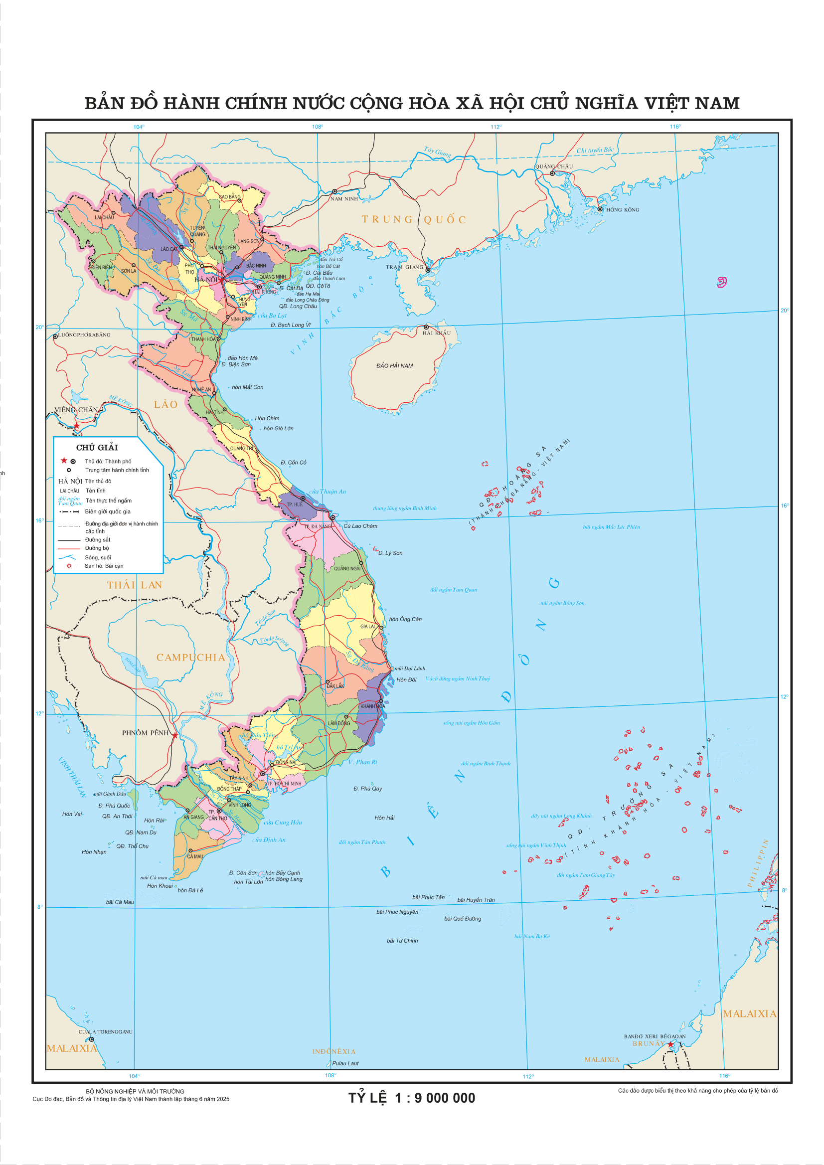
Vietnam possesses comprehensive historical, legal, geographical, and diplomatic foundations to affirm its indisputable sovereignty over the Hoang Sa and Truong Sa archipelagos. Below is a summary of the main pillars.
I. Historical Basis (17th - 19th Century)
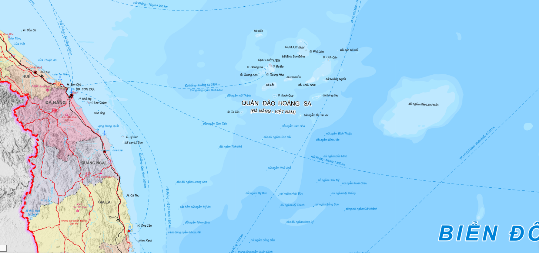
As early as the 17th century, when the Hoang Sa and Truong Sa archipelagos were still terra nullius (nobody's land), the Nguyen Lords in Đàng Trong (Southern Vietnam) established the Hoang Sa Flotilla (comprising about 70 able-bodied men from An Vinh commune, Quang Ngai) and the Bac Hai Flotilla (from Binh Thuan) to annually travel to the archipelagos to gather marine products, map maritime routes, plant trees, erect sovereignty markers, and build steles. This was the earliest, most continuous, and entirely peaceful form of state-organized exploitation and sovereignty enforcement, documented in Le Quy Don's Phu bien tap luc (1776).
The Nguyen Dynasty (1802-1945) continued and elevated this to a strict state administrative activity. Notably, the Chau ban of the Nguyen Dynasty (administrative documents bearing the Emperor's red ink approval, consisting of 19 units recognized by UNESCO as a Memory of the World) confirmed the dispatch of naval vessels to measure waterways and draw maps. In 1836, Emperor Minh Mang ordered Pham Huu Nhat to bring 10 wooden markers inscribed with the reign name to build a temple and plant sovereignty markers in Hoang Sa.
II. Cartographic Evidence & International Archives
Sovereignty is proven through a dense system of documents in Vietnam and the world: Toan tap Thien nam tu chi lo do thu (1686), Phu bien tap luc (1776), Hoang Viet dia du chi (1833), Dai Nam thuc luc (1844), Dai Nam nhat thong toan do (official map of the Minh Mang reign, 1838), and Bishop Taberd's An Nam dai quoc hoa do (1838). Remarkably, even Chinese documents such as the Huangchao zhishing diyu quantu (1904) indicate that China's southernmost territory only reached Hainan Island, completely excluding Hoang Sa and Truong Sa.
III. French Colonial Period (1884 - 1954)
Following the 1884 Treaty of Hue, France represented Vietnam in diplomacy and defense, continuing to exercise sovereignty over the two archipelagos. In the 1930s, the Indochinese government built meteorological stations, radio broadcasting stations, erected sovereignty steles, and maintained a permanent military presence in Hoang Sa. In 1938, the French administration erected a stele explicitly stating the Nguyen Dynasty's takeover year of 1816, affirming the continuity and inheritance of sovereignty from previous dynasties.
IV. Diplomatic Basis: 1951 San Francisco Conference
At the San Francisco Peace Conference on September 7, 1951, Prime Minister Tran Van Huu, head of the State of Vietnam delegation, solemnly declared the affirmation of Vietnam's sovereignty over the Hoang Sa and Truong Sa archipelagos before the representatives of 51 participating nations. Not a single country raised an objection to this declaration.
V. Modern International Legal Basis
Principle of "effective occupation": According to international law, Vietnam is the only nation to have exercised sovereignty over the two archipelagos peacefully, continuously, publicly, and without opposition for centuries when these territories were still terra nullius.
1982 United Nations Convention on the Law of the Sea (UNCLOS): As a state party, Vietnam established its sovereignty, sovereign rights, and jurisdiction over the 12-nautical-mile territorial sea, contiguous zone, 200-nautical-mile exclusive economic zone, and continental shelf in accordance with the Convention. On November 12, 1982, the Government of Vietnam published the Declaration on the baseline used to measure the breadth of the territorial sea.
Vietnam Law of the Sea 2012: Passed by the National Assembly on June 21, 2012 (effective January 1, 2013), it codified the provisions of UNCLOS 1982 and clearly affirmed that the Hoang Sa and Truong Sa archipelagos fall under the sovereignty, sovereign rights, and national jurisdiction of Vietnam.
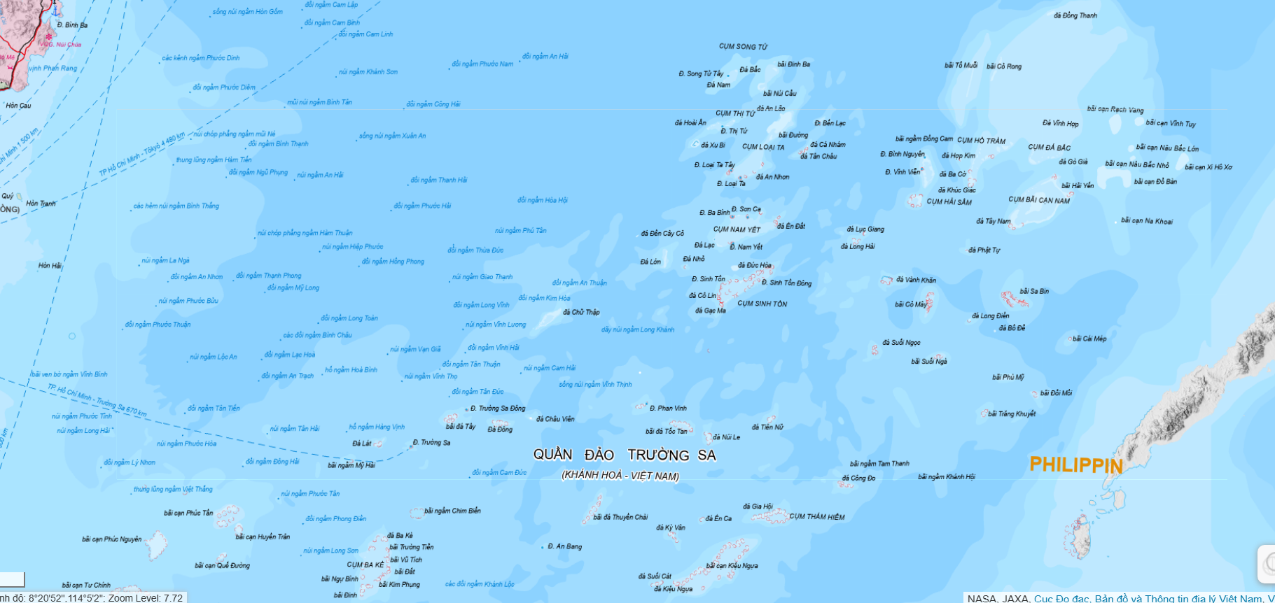
2016 International Arbitral Tribunal Ruling: Although Vietnam was not a party to the Philippines - China case, the Arbitral Tribunal constituted under Annex VII of UNCLOS declared that the "nine-dash line" claim used by China to assert sovereignty over the East Sea has no legal basis under international law.
VI. White Papers of the Government of Vietnam
The Ministry of Foreign Affairs of Vietnam has published three official White Papers affirming sovereignty: the 1979 White Paper ("Vietnam's Sovereignty over the Hoang Sa and Truong Sa Archipelagos"), the 1981 White Paper, and the 1988 White Paper (following the Gac Ma incident). These White Papers provide a comprehensive system of historical and legal evidence and strongly condemn any acts of using force to violate territorial sovereignty.
Vietnam persists in its stance of resolving all disputes through peaceful means, based on international law, including UNCLOS 1982, the UN Charter, and the Declaration on the Conduct of Parties in the South China Sea (DOC). Any occupation by force, regardless of when it occurs, violates the UN Charter and cannot establish a legitimate title of sovereignty.